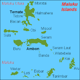
Geography
 |
| Location of the Aru Islands among the Maluku Islands |
Economy
Pearl farming is a major source of income for the island. The Aru pearl industry has been criticized in national media for allegedly maintaining exploitive debt structures that bind the local men who dive for pearls to outside boat owners and traders in an unequal relationship. Other export products include sago, coconuts, tobacco, mother of pearl, trepang (an edible sea cucumber, which is dried and cured), tortoiseshell, and bird of paradise plumes.History
The Aru Islands have a long history as a part of extensive trading networks throughout what is now eastern Indonesia. Precolonial links were especially strong to the Banda Islands, and Bugi and Makasarese traders also visited regularly. The islands were for colonized by the Dutch beginning 1623, though initially the Dutch East India Company was one of several trading groups in the area, with limited influence over the islands' internal affairs. In the nineteenth century, Dobo, Aru's largest town, temporarily became an important regional trading center, serving as a meeting point for Dutch, Makasarese, Chinese, and other traders. The period from the 1880s to 1917 saw a backlash against this outside influence, by a spiritually-based movement among local residents to rid the islands of outsiders.Demographics
Most indigenous islanders are of mixed Malay and Papuan descent. Fourteen languages - Barakai, Batuley, Dobel, Karey, Koba, Kola, Kompane, Lola, Lorang, Manombai, Mariri, East Tarangan, West Tarangan, and Ujir - are indigenous to Aru. They belong to the Central Malayo-Polynesian languages, and are related to the other languages of Maluku, Nusa Tenggara, and Timor. Ambonese Malay is also spoken on Wamar. All are members of the Austronesian language family. The population is mostly Christian, with a small Muslim minority, who are mainly migrants from other parts of Indonesia.http://www.bookrags.com/wiki/Aru_Islands
Komentar